
Maritime Domain Awareness in European Arctic Regions With VHR Satellite Intelligence
With the Arctic warming nearly four times faster than the average, the ice in the High North is melting and the sea is becoming increasingly navigable. In 2025 alone, 1812 vessels entered the Arctic Polar Code area, which is a 40% increase since 2013 when data collection began. While this rise in traffic presents potential commercial opportunities, more vessels also mean more risks to people and resources.

Satellite Imagery Protecting Europe’s Oceans
The ocean is a precious resource that all Europeans make use of in one way or another. Over 200 million of us live near the
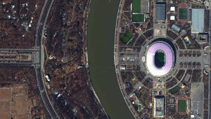
FIFA World Cup 2018 Stadiums As Seen From Space
The FIFA World Cup 2018 tournament will kick off in Russia tomorrow and to celebrate this great sporting event European Space Imaging have released satellite

Satellite Image Shows Massive Royal Wedding Crowds
Prince Harry and Meghan Markle were married at St George’s Chapel in the ground of Windsor Castle on Saturday, and European Space Imaging was lucky
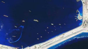
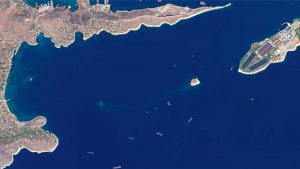
Satellite Images Unveil Completed Chinese Military Fortresses in Spratly Islands
Recent satellite images supplied and analysed by European Space Imaging reveal the illegal construction of military bases in the contested Spratly Islands along the South
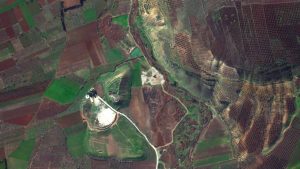
Satellite Images of Afrin Identify Massive Damage to Ancient Temple
Satellite imagery supplied by European Space Imaging shows that more than half of an ancient temple near the town of Afrin, Syria, has been reduced

Dr Wolfgang Steinborn Awarded DDGI’s Golden Badge of Honor
Dr Wolfgang Steinborn, a Senior Advisor at European Space Imaging, has been awarded the prestigious golden badge of honor by the German Umbrella Organization for
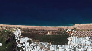
Satellite Images of West Attica Flood Help Government Response
A flood west of Athens, Greece, was caused by heavy rain on November 15-16, and has killed 22 people. The cities of Mandra, Elefsina, and
Satellite Images of Turkey Show Whirlwind Damage
A whirlwind hit the Mediterranean Coast in the province of Antalya, Turkey, injuring 38 people and causing significant damage to agricultural land, cars, and houses.

European Space Imaging Celebrates 15 Years of Success
We are proud to announce our 15th year as the leading premium supplier to the remote sensing industry, offering the highest spatial resolution imagery currently
Satellite Images Show Europe’s Diversity in New Book
European Space Imaging have partnered with EOVision to produce a book entirely comprised of satellite imagery showcasing the diversity of Europe as seen from space.

Keyne Eye: Smart Urban Planning
Milton Keynes is one of the fastest growing cities in the UK and a great economic success story. However, the challenge of supporting sustainable growth
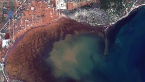
Greece: Satellite Images Show Oil Spill
A tanker carrying 2,500 tonnes of oil and fuel sank near Athens on September 10, polluting the Greek coastline. European Space Imaging captured a series


