Vital for infrastructure, transportation and emergency response applications, our advanced mapping solutions mean you spend less time making maps and more time making progress. Our imagery, expertise, partnerships and custom solutions offer the best options for mapping projects requiring speed, accuracy and scalability.
Leverage valuable insights
AI Feature Extraction
Our mapping solutions let you spend less time creating maps and more time doing analysis
Geospatial accuracy
Not only the highest resolution imagery, but the most locationally accurate as well
Large Scale Mapping
Custom tailored solutions for country wide mapping at Very High Resolution
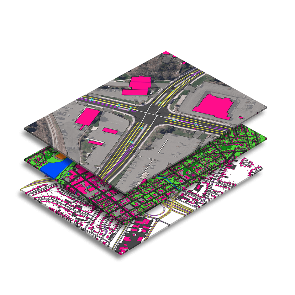
Ecopia GFX
By European Space Imaging
Ecopia Global Feature Extraction (GFX) Powered by European Space Imaging is a unique partnership that utilises the freshest, highest quality satellite imagery along with the most advanced artificial intelligence from Ecopia.AI (Ecopia) to offer accurate geospatial feature extraction at continent-wide scale. The product comes with up to 13 core features eligible for extraction, so users can receive comprehensive land cover maps with zero in-house GIS work.
The resulting vector maps are delivered as easy-to-use shapefiles, enabling users to focus on necessary analytics rather than time consuming map making.
We offer not only the highest quality imagery for detection of road lines, but also mapping products specifically tailored for road feature mapping and autonomous driving navigation.
The advantages are clear:
True 30 cm imagery and 15 cm HD imagery allow road lines and traffic features to be easily identified.
Satellites provide scalability at relative ease compared to aerial options.
Automated feature extraction details not only streets, but driveways, parking lots, railroads and sidewalks.
The 3D revolution is upon us and European Space Imaging has teamed up with top innovators in elevation data to provide our users with the fastest, most accurate and visually detailed models.
Digital Elevation Models (DEM) allow users to make quantitative and holistic analysis across every industry – answering questions such as:
How tall is this vegetation?
Where will flood waters settle in this city?
Where can we land a helicopter?
Will nearby buildings block sun to these solar panels?
Is there a direct line-of-sight between points A and B?
European Space Imaging has worked with EU-funded emergency response and mapping services for over 17 years. We are the longest European provider to offer True 30 cm resolution imagery. This benefit paired with our unique ability to accept emergency orders 24/7 and deliver within 30 minutes of collection positions us as the leader in space-based natural disaster and humanitarian crisis monitoring in Europe.
Access to high quality imagery and maps in the hours immediately following a disaster give first responders the highest probability of saving lives and mitigating damages.
This website uses cookies to improve your experience. We'll assume you're ok with this, but you can opt-out if you wish.DENYCUSTOMIZEACCEPT ALL
Privacy & Cookies Policy
Privacy Overview
This website uses cookies to improve your experience while you navigate through the website. Out of these cookies, the cookies that are categorized as necessary are stored on your browser as they are essential for the working of basic functionalities of the website. We also use third-party cookies that help us analyze and understand how you use this website. These cookies will be stored in your browser only with your consent. You also have the option to opt-out of these cookies. But opting out of some of these cookies may have an effect on your browsing experience.
Necessary cookies are absolutely essential for the website to function properly. This category only includes cookies that ensures basic functionalities and security features of the website. These cookies do not store any personal information.
Any cookies that may not be particularly necessary for the website to function and is used specifically to collect user personal data via analytics, ads, other embedded contents are termed as non-necessary cookies. It is mandatory to procure user consent prior to running these cookies on your website.
Architecture of ResNet34-UNet model
UNet architecture for semantic segmentation with ResNet34 as encoder or feature extraction part. ResNet34 is used as an encoder or feature extractor in the contracting path and the corresponding symmetric expanding path predicts the dense segmentation output.
Architecture of VGG16-UNet model
UNet architecture for semantic segmentation with VGG16 as the encoder or feature extractor. VGG16 is used as an encoder or feature extractor in the contracting path and the corresponding symmetric expanding path predicts the dense segmentation output.
Architecture of ResNet34-FCN model
In this model, ResNet34 is used for feature extraction and the FCN operation remains as is. The feature of ResNet architecture is exploited where just like VGG, as the number of filters double, the feature map size gets halved. This gives a similarity to VGG and ResNet architecture while supporting deeper architecture and addressing the issue of vanishing gradients while also being faster. The fully connected layer at the output of ResNet34 is not used and instead converted to fully convolutional layer by means of 1×1 convolution.
Architecture of VGG16-FCN model
In this model, VGG16 is used for feature extraction which also performs the function of an encoder. The fully connected layer of the VGG16 is not used and instead converted to fully convolutional layer by means of 1×1 convolution.