
Earth Observation Turns Ecological Targets into Measurable Outcomes: How Satellite Imagery Supports Compliance with Europe’s Nature Restoration Regulation
The EU’s Nature Restoration Regulation (NRR) entered into force in 2024 and set legally binding targets to restore degraded ecosystems across Europe. With National Restoration Plans due in September 2026, Member States face an urgent question: how do you map, plan and monitor restoration across millions of hectares in a consistent, verifiable way? Earth Observation (EO) – and Very High Resolution (VHR) multispectral satellite imagery in particular – is increasingly the answer.

New Solution for EU Urban Planning Challenge
A sweeping urban planning initiative, the European Union Strategic Environmental Assessment (SEA) Directive of 2001 is a complex set of procedures and processes that ensure

30 cm WorldView-3 Imagery Products Available Now
European Space Imaging is excited to announce we are now accepting orders for 30 cm WorldView-3 satellite imagery products. According to DigitalGlobe users can expect
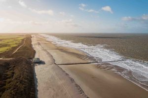
Protecting the Dutch Coast With Satellites
Digital Surface Models (DSM) are key components for urban planning, biomass estimation and many more. With nearly 50 percent of its landmass lying at or

Protecting a Precious Biosphere With Satellites
With a return to democracy in 2008 after decades of military rule, world interest in Myanmar is increasing. A country rich in beauty and natural
QuickBird De-Orbited
European Space Imaging announced today that on Tuesday 27 January 2015, after 13 years of excellent performance, QuickBird approached its end of mission smoothly and,

European Space Imaging and TotalView Provide Satellite Imagery for Greek LPIS 2014 Project
European Space Imaging and TotalView successfully completed the provision of DigitalGlobe’s (DG) satellite imagery products for the Land Parcel Identification System (LPIS) 2014 project in

Digitising the Third Dimension
Digital Surface Models (DSM) are key components for urban planning, biomass estimation and many more tasks where 3-dimensional data is required. Traditionally, the imagery for
Satellite Imagery Tasking From WorldView-3 Now Available
European Space Imaging is excited to announce we are now accepting new tasking orders for WorldView-3 satellite. Imagery tasking is available for worldwide collections as
Worldwide 40 cm Global Imagery Tasking Now Available
European Space Imaging and the WorldView Global Alliance are excited to announce we are now accepting orders for new tasking collections for 40 cm DigitalGlobe
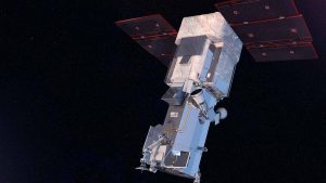
First Images From WorldView-3
On August 13, 2014, DigitalGlobe launched WorldView-3 into orbit. On August 19, a mere six days after launch, they completed commissioning the satellite bus and
Seeing the Invisible: Carbon Leaks
With worldwide coal-powered plant capacity set to increase by 35% before 2020 and hence increase the annual amount of Carbon Dioxide (CO2) generated by many
Space Scout: A Site for Speed
Selecting and preparing the site where the Bloodhound supersonic car (SSC), hopefully the world’s first car to reach a speed of 1,000 miles per hour


