


VHR Satellite Images for Wildfire Monitoring
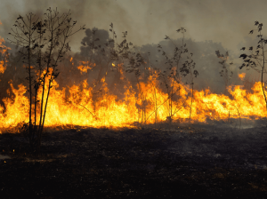
High temperatures are breaking records, vegetation is drying up, and catastrophic wildfires are raging across Europe. Emergency responders are already turning to satellite imagery for fire monitoring and damage analysis – but few know its full potential. Near Real-Time (NRT) capabilities deliver critical images just 15 minutes after collection. Intraday imaging captures a fire as it develops throughout the day. And 8-band multispectral imagery lets responders see through haze, light fog, and other atmospheric conditions – including wildfire smoke itself.

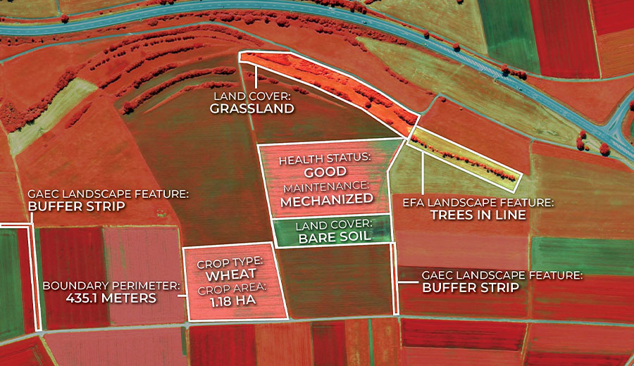
Earth Observation Turns Ecological Targets into Measurable Outcomes: How Satellite Imagery Supports Compliance with Europe’s Nature Restoration Regulation
The EU’s Nature Restoration Regulation (NRR) entered into force in 2024 and set legally binding targets to restore degraded ecosystems across Europe. With National Restoration Plans due in September 2026, Member States face an urgent question: how do you map, plan and monitor restoration across millions of hectares in a consistent, verifiable way? Earth Observation (EO) – and Very High Resolution (VHR) multispectral satellite imagery in particular – is increasingly the answer.

EUSI Upgrades German Ground Segment to Enable Europe’s Fastest Request-to-Receive Satellite Intelligence via Secure Web and API Platform for Defence and Emergency Agencies
European Space Imaging (EUSI) announced a major upgrade of its satellite ground segment and cloud infrastructure, further accelerating its industry-leading satellite tasking and intelligence delivery capabilities through the secure ATOM™ web and API platform. The platform, in combination with EUSI’s Rapid Satellite Intelligence (RSINT) program, enables satellite tasking up to 30 minutes before image acquisition and delivery of imagery within 15 minutes of collection.


