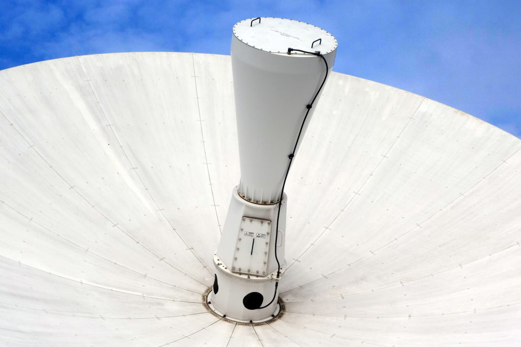
EUSI Upgrades German Ground Segment to Enable Europe’s Fastest Request-to-Receive Satellite Intelligence via Secure Web and API Platform for Defence and Emergency Agencies
European Space Imaging (EUSI) announced a major upgrade of its satellite ground segment and cloud infrastructure, further accelerating its industry-leading satellite tasking and intelligence delivery capabilities through the secure ATOM™ web and API platform. The platform, in combination with EUSI’s Rapid Satellite Intelligence (RSINT) program, enables satellite tasking up to 30 minutes before image acquisition and delivery of imagery within 15 minutes of collection.
European Space Imaging Announces New Partnership With Vricon
European Space Imaging, Europe’s leading very high-resolution satellite imagery provider, has entered into an agreement with Vricon, the leader in high-accuracy 3D data and digital

WorldView-1 Successfully Changes Orbit
European Space Imaging customers now benefit from more imaging access windows over Europe due to WorldView-1’s orbit change. WorldView-1 now moves in an afternoon orbit

Spots from Space: Fair Access to Greek Beaches
Greece has the longest tourist coastline in Europe, and its beaches are the property of all citizens. Each summer, coastal municipalities grant permits for hotels

Optimising Wine With Data From Space
The Remote Sensing Laboratory at the National Technical University of Athens, Greece, successfully correlated vegetation indices derived from pansharpened multispectral WorldView-2 data with ground-based measurements

How Satellite Imagery Helps Protect UNESCO World Heritage Sites
When the Islamic State (IS) was rumored in the media to have destroyed two cultural heritage sites in Iraq – Hatra and Nimrud – officials

European Space Imaging Wins Additional Supply Contract to European Commission
The Munich-based company has been awarded another major supply contract for VHR satellite data and services to support checks within the EU Common Agricultural Policy

Mt Etna’s Volcanic Plumes Imaged by WorldView-2 Satellite
WorldView-2 satellite captured the fumarole plumes of smoke and gas that continue to spout from the crater shortly after the eruption on 3 December. The

European Space Imaging Delivers 100% Success For CwRS 2015
European Space Imaging completed the 2015 Controls with Remote Sensing (CwRS) program for the European Commission (EC) with 100 % success rate. The Munich-based company

MEP Sees Growing Responsibilities for High-Precision Satellite Observation Technology
Dr. Angelika Niebler visits European Space Imaging. Europe’s leading provider of high-resolution satellite imagery received a visit last Tuesday from Dr. Angelika Niebler, Member of
Satellite Imagery Keeps Port Construction on Track
The New Port Project (NPP) in the State of Qatar is one of the world’s most ambitious Greenfield port developments. A true megaproject, the four-year

IKONOS Decommissioned
IKONOS outlived many of its younger siblings but today it is time to say goodbye. After 15-plus years of successful service, DigitalGlobe made the decision

New Solution for EU Urban Planning Challenge
A sweeping urban planning initiative, the European Union Strategic Environmental Assessment (SEA) Directive of 2001 is a complex set of procedures and processes that ensure


