

VHR Satellite Images for Wildfire Monitoring
- Zuzana Hajkova, Content Marketing Coordinator, EUSI
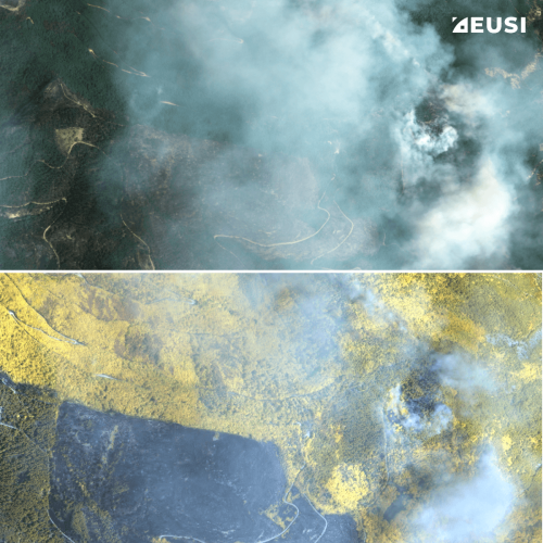
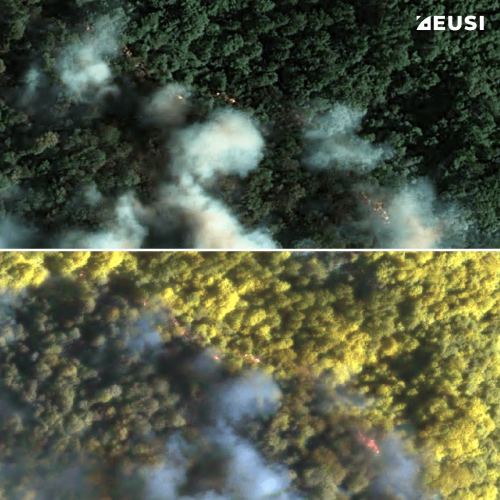
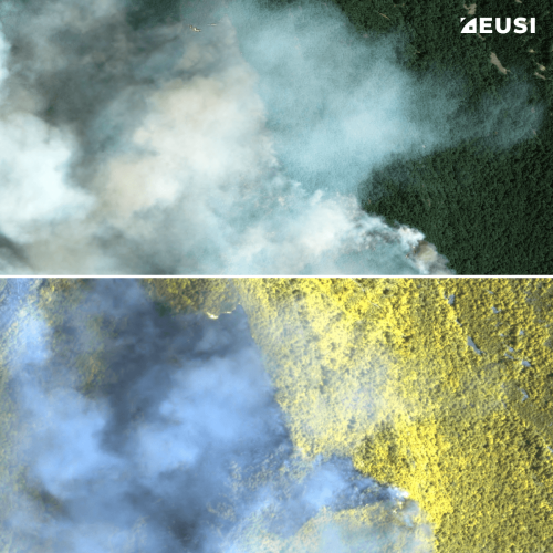
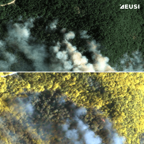
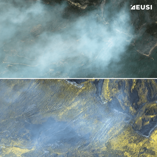
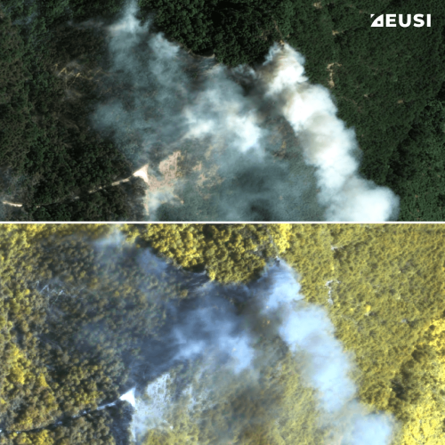
High temperatures are breaking records, vegetation is drying up, and catastrophic wildfires are raging across Europe. Emergency responders are already turning to satellite imagery for fire monitoring and damage analysis – but few know its full potential. Near Real-Time (NRT) capabilities deliver critical images just 15 minutes after collection. Intraday imaging captures a fire as it develops throughout the day. And 8-band multispectral imagery lets responders see through haze, light fog, and other atmospheric conditions – including wildfire smoke itself.
Using multispectral satellite images to see through the smoke
Heat and smoke are among the biggest obstacles to monitoring a wildfire. Flying over the burning area is often unsafe, and even when aircraft can get airborne, smoke obscures the view and limits what can actually be extracted from the images. Satellites solve both problems at once: they cover the entire fire area safely and quickly in a single pass, and with 8 multispectral bands, they can partially reveal what’s hiding underneath the smoke.
What are multispectral satellite images?
The human eye sees colour in the 400–700 nm wavelength range. Some satellite sensors see far more than that. They show wavelengths invisible to us, like near-infrared and red edge, which reveal information such as vegetation health, soil moisture, and material composition. Imagery that captures these extra wavelengths is called multispectral, and it’s this extended range that makes seeing through smoke possible.
Less smoke, more visibility
While other providers collect 4-band or 6-band multispectral imagery, EUSI is the only provider who offers 8-band Very High Resolution (VHR) satellite imagery in Europe and North Africa. These are the included bands:
- WorldView-2 and -3: Coastal, blue, green, yellow, red, red edge, NIR1, NIR2
- WorldView Legion: Coastal, blue, green, yellow, red, red edge 1, red edge 2, NIR
The additional multispectral bands – red edge and near-infrared (NIR) – enable smoke processing. They let responders see details that would otherwise stay hidden, making it easier to pinpoint exactly where a fire is burning and assess the damage it has caused.


Interoperability with Sentinel
Low resolution satellites, such as the EU’s Sentinel, are often used for large-scale monitoring of wildfires, and it can be complicated to combine them with VHR data – because different satellites have different spectral bands. Emergency responders then have to work with different processing chains, additional calibration, or compromises. To solve this problem, Vantor WorldView Legion’s multispectral bands were designed to closely align with Sentinel-2.
With bands that correspond to Sentinel-2’s most widely used spectral regions, analysts can integrate VHR imagery into existing workflows with minimal adaptation. They can:
- validate or investigate Sentinel-2 observations at up to 30 cm resolution,
- apply familiar indices and analysis methods,
- combine regional monitoring with detailed site-level investigation,
- move between broad-area screening and high-resolution intelligence using comparable spectral information.
Comparison of the spectral bands of Vantor WorldView-2 & 3, WorldView Legion and Sentinel 2
Intraday imaging: watching a fire in motion
More satellites in orbit means more chances to collect the same fire area, and more images collected in a single day translate directly into better decisions on the ground. With multiple daily collections, responders can track how a fire is spreading in near real time, calculate how fast the fire line is moving to anticipate where it will be next, and simply wait out a cloud bank instead of losing the day’s imagery entirely.
The Vantor constellation operated by EUSI currently consists of 10 VHR satellites, offering up to 15 collection opportunities per day, depending on location. The example below shows two images of a 2025 wildfire in Portugal: the second one collected only 35 minutes after the first one.
Intraday imaging of a wildfire in Portugal. Satellite Imagery © 2026 Vantor Provided by European Space Imaging
That same revisit frequency also solves a more mundane but equally critical problem: cloud cover. With so many passes available over a single area, EUSI can simply keep collecting until the clouds clear and the fire is fully visible.
Intraday collections enable cloud cover optimisation.
When every minute matters
Imagine this scenario: A wildfire starts raging near an urban area. Lives are at stake but due to the smoke and heat, it’s impossible to precisely map the extent of the fire and possible evacuation routes. Every minute matters, and without access to comprehensive information, emergency response is slower and harder than it needs to be.
With satellite imagery, it often takes hours to receive usable data. That’s why EUSI upgraded their German ground station and enabled Europe’s fastest request-to-receive satellite intelligence. Users can task satellite collections, as well as order archive imagery, through the secure ATOM™ web and API platform which enables satellite tasking up to 30 minutes before image acquisition and delivery of imagery within 15 minutes of collection.
At 8:00, a fire breaks out. At 8:15, you task a satellite collection. At 9:00, the image arrives. In emergency response, this speed can save lives.
An example of RSINT (Rapid Satellite Intelligence)
From satellite to first responders
Raw imagery is only the starting point. EUSI works closely with partners like Copernicus EMS, GAF Geospatial, Sertit or Kayrros to turn imagery into rapid mapping products: detailed delineation maps, grading maps, and other impact analyses that responders can act on directly.
8-band multispectral VHR imagery, delivered in near real time, gives firefighters and emergency response teams the best available basis for fast, informed decisions – decisions that mitigate risk, limit damage, and save lives.
Related Stories

Earth Observation Turns Ecological Targets into Measurable Outcomes: How Satellite Imagery Supports Compliance with Europe’s Nature Restoration Regulation
The EU’s Nature Restoration Regulation (NRR) entered into force in 2024 and set legally binding targets to restore degraded ecosystems across Europe. With National Restoration Plans due in September 2026, Member States face an urgent question: how do you map, plan and monitor restoration across millions of hectares in a consistent, verifiable way? Earth Observation (EO) – and Very High Resolution (VHR) multispectral satellite imagery in particular – is increasingly the answer.

EUSI Upgrades German Ground Segment to Enable Europe’s Fastest Request-to-Receive Satellite Intelligence via Secure Web and API Platform for Defence and Emergency Agencies
European Space Imaging (EUSI) announced a major upgrade of its satellite ground segment and cloud infrastructure, further accelerating its industry-leading satellite tasking and intelligence delivery capabilities through the secure ATOM™ web and API platform. The platform, in combination with EUSI’s Rapid Satellite Intelligence (RSINT) program, enables satellite tasking up to 30 minutes before image acquisition and delivery of imagery within 15 minutes of collection.

Maritime Domain Awareness in European Arctic Regions With VHR Satellite Intelligence
With the Arctic warming nearly four times faster than the average, the ice in the High North is melting and the sea is becoming increasingly navigable. In 2025 alone, 1812 vessels entered the Arctic Polar Code area, which is a 40% increase since 2013 when data collection began. While this rise in traffic presents potential commercial opportunities, more vessels also mean more risks to people and resources.


Seeing More in a Single Day: The Value of Intraday Satellite Collections
Imagine a convoy moves between 08:00 and 11:00. Or morning clouds clear by 14:00, revealing new activity. Or a structure appears at 09:30 that wasn’t visible at 07:00. If you’re working with once-daily satellite passes, you miss all of this. With intraday collections, you see it happen.



