
Maritime Domain Awareness in European Arctic Regions With VHR Satellite Intelligence
With the Arctic warming nearly four times faster than the average, the ice in the High North is melting and the sea is becoming increasingly navigable. In 2025 alone, 1812 vessels entered the Arctic Polar Code area, which is a 40% increase since 2013 when data collection began. While this rise in traffic presents potential commercial opportunities, more vessels also mean more risks to people and resources.
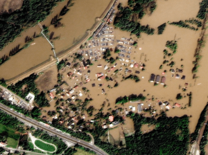
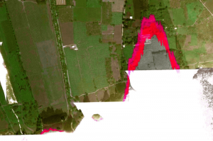
Synchronised Collections of SAR and VHR Optical Satellite Imagery Revolutionise Flood Management
As climate change accelerates, the frequency and severity of flooding events are becoming increasingly alarming. In response, innovative tools like DoubleShot, developed by European Space Imaging in partnership with Umbra, are transforming flood management strategies. By combining the power of Very High Resolution (VHR) Synthetic Aperture Radar (SAR) and Optical satellite imagery, DoubleShot delivers a comprehensive, weather-independent solution for near real-time flood mapping and monitoring.
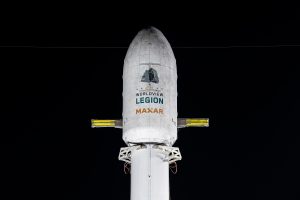
EUSI Will Soon Offer Intraday Monitoring Across Europe After Maxar’s Second Successful Launch of WorldView Legion Satellites
With the successful launch of Maxar Intelligence’s second set of WorldView Legion satellites, European Space Imaging (EUSI) will soon offer up to eight daily collection opportunities in key latitudes across Europe and North Africa – a number that will increase after the final WorldView Legion satellites are launched and all six satellites are operational.
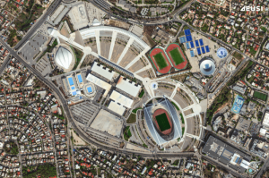
A Bird’s-Eye View: Olympic Stadiums of Europe from Space
The whole world is watching the Olympic Games in Paris with bated breath. But it’s not the first time the Summer Olympics have been held in Europe – 14 stadiums have been built across 10 countries, each of them unique and capturing the spirit of the cities that hosted them. Which one is your favourite?
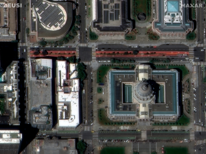
Maxar Intelligence Releases First Images from WorldView Legion as EUSI Prepares Munich Ground Station for European Downlink
Satellite Imagery © 2024 Maxar Technologies Provided by European Space Imaging Munich, Germany – Maxar Intelligence released the first images collected by the highly anticipated
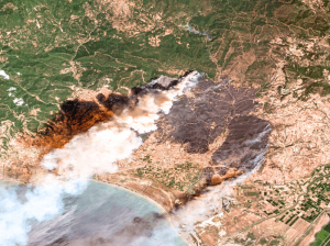
Satellite Imagery for Emergency Management
The use of satellite imagery for emergency response and management is invaluable. Both optical and SAR images help rescuers save lives when disasters happen, assist with damage assessments, and in many cases contribute to successfully preventing and predicting emergencies. Which events can be prevented? How exactly do first responders use satellite images? When are they better than other methods? We have summarised our 20+ years of experience in this article.
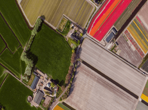
Satellite Imagery as a Valuable Tool for the New Common Agricultural Policy 2023–2027
On 1 January 2023, the new Common Agricultural Policy for years 2023–2027 entered into force. Hand in hand with the provided subsidies goes the necessity for monitoring and controls, which falls to the individual Member States. Therefore, an efficient, reliable, and cost-effective source of data is needed. Such source is Very High Resolution (VHR) satellite imagery. It allows you to conduct in-depth analysis of plant and soil conditions, map land use at wide scales with incredible detail and accuracy, and ensure that agricultural goals are being met.
What is SAR Imagery? Introduction to Synthetic Aperture Radar
SAR imagery enables all-weather monitoring, penetrates dry soil, and offers resolution as high as 25 cm. Thanks to that, it’s invaluable for applications like emergency response, defence and intelligence, or agriculture. How does SAR work? What are its advantages and limitations? And what other data sources can you integrate it with? Read the article to learn more.
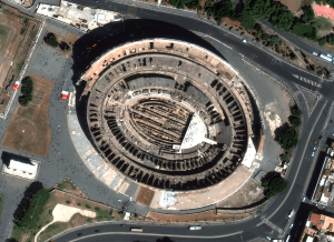
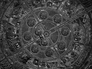
18 European Landmarks in Satellite Images
Satellite sensors captured unique architecture, breathtaking nature and centuries of history. Explore the Colloseum, La Sagrada Familia, the Leaning Tower of Pisa, and other landmarks.
Understanding ONA in Satellite Imagery: What is Off Nadir Angle and What Is It Used For?
Off Nadir Angle (ONA) plays a crucial role in the quality of optical satellite imagery. It influences its resolution and clarity, decides the visibility of features, and makes it easier or harder to identify objects. Moreover, ONA is used to create stereo imagery and 3D models of the Earth’s surface. Read on to learn more.
Sun Glint Can Ruin Satellite Imagery. How Do We Avoid It?
Sun glint occurs when sunlight reflects off water or another reflective surface at the satellite sensor, creating a bright glare in the image. That can make it impossible to extract useful information from satellite imagery. What do we do to minimise its impact?
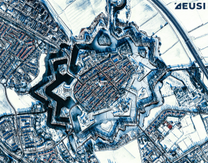
What do Star Forts Look Like From Space? 20 Satellite Images That Will Take Your Breath Away
Star forts are not only perfect examples of effective military engineering; they are also beautiful. Let’s join us on a fascinating journey through architecture and history – from space. All satellite images in this article were collected by WorldView-3, WorldView-2 or GeoEye-1 at 30–50 cm resolution.
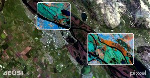
EUSI and Pixxel Partner to Bring the World’s Best Hyperspectral Imagery to the European Market
Munich, Germany, Los Angeles, California, and Bangalore, India – European Space Imaging (EUSI), a leading provider of Very High Resolution (VHR) satellite imagery and Pixxel,


