
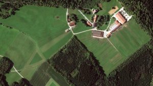
Earth Observation Turns Ecological Targets into Measurable Outcomes: How Satellite Imagery Supports Compliance with Europe’s Nature Restoration Regulation
The EU’s Nature Restoration Regulation (NRR) entered into force in 2024 and set legally binding targets to restore degraded ecosystems across Europe. With National Restoration Plans due in September 2026, Member States face an urgent question: how do you map, plan and monitor restoration across millions of hectares in a consistent, verifiable way? Earth Observation (EO) – and Very High Resolution (VHR) multispectral satellite imagery in particular – is increasingly the answer.

Keyne Eye: Smart Urban Planning
Milton Keynes is one of the fastest growing cities in the UK and a great economic success story. However, the challenge of supporting sustainable growth
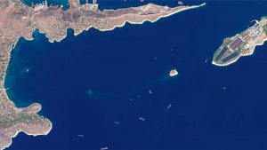
Greece: Satellite Images Show Oil Spill
A tanker carrying 2,500 tonnes of oil and fuel sank near Athens on September 10, polluting the Greek coastline. European Space Imaging captured a series
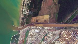
Satellite Images Of Flooding In Livorno, Italy
Eight people have lost their lives in flooding caused by heavy rain on the 9th and 10th of September in the port city of Livorno.

Myanmar Satellite Images Show Massive Fire Destruction
700 buildings destroyed in single Muslim village in Rakhine State. New satellite imagery captured by DigitalGlobe satellite GeoEye-1 and supplied by European Space Imaging shows
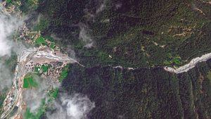
Seen From Space: Landslide in the Swiss Alps
Eight people are missing after a massive landslide in Bondo, near the Italian border in the south of Switzerland. On Wednesday August 23rd a huge
European Space Imaging Delivers 100% Success Rate For European Commission
Speedy delivery and quality imagery mark European Space Imaging’s acquisitions for the 2017 CwRS CAP program. Early last week European Space Imaging finalized the collection

WorldView-4 Increases European Space Imaging’s Satellite Tasking Capacity
The world’s highest resolution satellite constellation has doubled in it’s 30 cm capacity. On November 11, 2016, the WorldView-4 satellite was launched into space as

European Space Imaging Starts Distribution of WorldView-4 Satellite Imagery
A new ground station and a unique 30 cm satellite constellation enable unprecedented capabilities. European Space Imaging announced today that the company has started operations
European Space Imaging Awarded Supply Contract by European Commission
The Munich-based company has been awarded another major supply contract for VHR satellite data and services to support checks within the EU Common Agricultural Policy

European Space Imaging Partner in Newly Launched MARSAT Consortium
MARSAT consortium announced it is ready to provide innovative space-based applications using satellite-derived information for the maritime and coastal industry. MARSAT’s main goal is to
Planetek Italia and European Space Imaging Support Earthquake Emergency
European Space Imaging and its long-term partner Planetek Italia sprang into action to support disaster relief efforts by supplying the first available very high-resolution satellite
Amatrice, Italy, Before and After the Quake
On hearing about the earthquake early this morning European Space Imaging’s satellite tasking operations team managed to collect the first satellite image of the damage


