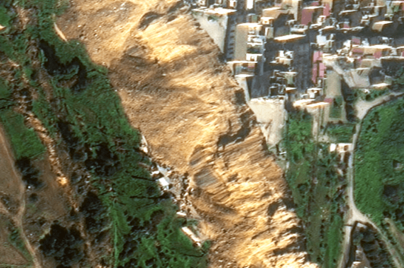
VHR Satellite Images Show Damage After Niscemi Landslide
In January 2026, Italy declared state of emergency after being hit by Cyclone Harry – a storm that brought 10-metre waves and torrential rains of over 300 mm in 48 hours. The most severely affected regions were Sicily, Calabria and Sardinia, with the damage in Sicily alone estimated to be more than 1.5 billion euros. EUSI collected Very High Resolution satellite imagery of the affected areas, including Niscemi – a Sicilian town hit by a massive landslide.
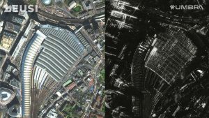
EUSI Partners with Umbra to Offer SAR Imagery to European Remote Sensing Projects
Munich, Germany – European Space Imaging (EUSI), a leading provider of Very High Resolution (VHR) optical satellite imagery, is pleased to announce a strategic partnership

How 8-Band Multispectral VHR Satellite Imagery Sees Through Smoke in the Mediterranean Fires
As forest fires tear through multiple nations around the Mediterranean Sea, European Space Imaging (EUSI) is aiding emergency responders with rapid delivery of Near Real-Time

EUSI Invests in Ground Station Upgrade at the German Aerospace Center (DLR) for the Fastest VHR Satellite Imagery Delivery in Europe
Munich, Germany – European Space Imaging (EUSI), the leading provider of Very High Resolution (VHR) satellite imagery in Europe, is thrilled to announce a multi-million

European Space Imaging and Airbus partner to provide EMSA with best-in-class satellite imagery service
The European Maritime Safety Agency (EMSA) has awarded European Space Imaging (EUSI) and Airbus a 24 month contract for the delivery of the Very High

Supporting European Land Management Policies via Copernicus VHR2021
Skye Boag, Marketing Manager EUSI have delivered over one million sq km of cloud free satellite data to the Copernicus VHR2021 campaign in cooperation with

European Space Imaging becomes EUSI
We are excited to announce that European Space Imaging are rebranding to the acronym of EUSI. After more than 20 years in the Earth Observation business,

Managing Solar Energy with Satellite Based Earth Observation
While Russia remains in conflict with Ukraine, and the future of the Russian oil and gas supply is uncertain, the EU is now faced with

Rivers and Lakes are Drying as Europe Faces Worst Drought in 500 Years
According to the report “Drought in Europe” released in July 2022 by the European Commission Joint Research Centre (JRC) Global Drought Observatory, a staggering portion

Detecting Bark Beetle Damage in Bulgaria
In recent years, large outbreaks of the European spruce spark beetle (Ips typographus) have wreaked havoc to coniferous forests. The timely prevention of the bark

Remote Sensing of Mass Movements in the Bavarian Alps
Mass movement in the Alps pose enormous hazards. Due to a range of factors, it is predicted that the associated risks of these movements will

European Space Imaging Renews Contract With Maxar Technologies To Provide Europe With The World’s Best Resolution Commercial Satellite Imagery
European Space Imaging and Space Imaging Middle East have extended their ongoing contract with Maxar Technologies, provider of comprehensive space solutions and secure, precise, geospatial
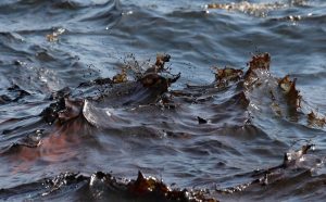
Increasing Situational Awareness of Conflict Linked Oil Pollution with VHR Satellite Imagery
Very High Resolution (VHR) satellite imagery is often used as a source of truth to verify what is happening on the ground in hard to


