
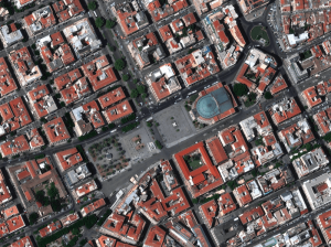
Earth Observation Turns Ecological Targets into Measurable Outcomes: How Satellite Imagery Supports Compliance with Europe’s Nature Restoration Regulation
The EU’s Nature Restoration Regulation (NRR) entered into force in 2024 and set legally binding targets to restore degraded ecosystems across Europe. With National Restoration Plans due in September 2026, Member States face an urgent question: how do you map, plan and monitor restoration across millions of hectares in a consistent, verifiable way? Earth Observation (EO) – and Very High Resolution (VHR) multispectral satellite imagery in particular – is increasingly the answer.
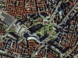

EUSI Upgrades German Ground Segment to Enable Europe’s Fastest Request-to-Receive Satellite Intelligence via Secure Web and API Platform for Defence and Emergency Agencies
European Space Imaging (EUSI) announced a major upgrade of its satellite ground segment and cloud infrastructure, further accelerating its industry-leading satellite tasking and intelligence delivery capabilities through the secure ATOM™ web and API platform. The platform, in combination with EUSI’s Rapid Satellite Intelligence (RSINT) program, enables satellite tasking up to 30 minutes before image acquisition and delivery of imagery within 15 minutes of collection.
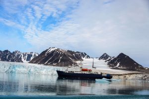
Maritime Domain Awareness in European Arctic Regions With VHR Satellite Intelligence
With the Arctic warming nearly four times faster than the average, the ice in the High North is melting and the sea is becoming increasingly navigable. In 2025 alone, 1812 vessels entered the Arctic Polar Code area, which is a 40% increase since 2013 when data collection began. While this rise in traffic presents potential commercial opportunities, more vessels also mean more risks to people and resources.
Seeing More in a Single Day: The Value of Intraday Satellite Collections
Imagine a convoy moves between 08:00 and 11:00. Or morning clouds clear by 14:00, revealing new activity. Or a structure appears at 09:30 that wasn’t visible at 07:00. If you’re working with once-daily satellite passes, you miss all of this. With intraday collections, you see it happen.
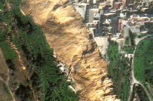
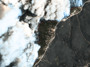
VHR Satellite Images Show Damage After Niscemi Landslide
In January 2026, Italy declared state of emergency after being hit by Cyclone Harry – a storm that brought 10-metre waves and torrential rains of over 300 mm in 48 hours. The most severely affected regions were Sicily, Calabria and Sardinia, with the damage in Sicily alone estimated to be more than 1.5 billion euros. EUSI collected Very High Resolution satellite imagery of the affected areas, including Niscemi – a Sicilian town hit by a massive landslide.
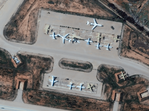
The Potential of WorldView Legion for the Safety and Security in Europe
In the ever-evolving landscape of global security, satellite imagery has become an indispensable tool for governments, organisations, and businesses worldwide. Many of them are now learning about the new opportunities that the six recently launched Vantor WorldView Legion satellites bring: higher border security, improved maritime surveillance, faster reaction to developing events, and much more.
Beginner’s Guide to Satellite Imagery: 10 Terms You Need to Know
Satellite imagery is an amazing but highly technical field with terms that might be hard to understand, especially for somebody with expertise in a completely different area. That’s why we are explaining the basics of satellite imagery in this article. What’s geolocational accuracy? What is the ideal off nadir angle? How can you see through clouds? Let’s dive right in.
Europe’s Green and Digital Transformations with 25 Years of VHR Satellite Archive Data
Planning Europe’s future without knowing its past is impossible. The European Green Deal, Horizon Europe, the EU Biodiversity Strategy for 2030 and other policies all demand one thing: evidence. Not just today’s data, but years of history that show how our cities, forests, and coastlines have changed.
AI Uses 15 cm Satellite Images to Cut Costs and Increase Scalability in Forest Management and Urban Forestry
Forest managers across Europe face an impossible task: monitor millions of hectares with shrinking budgets while meeting increasingly strict EU environmental targets. But with the rise of AI and satellite technology, they now have new solutions at their disposal – smarter, cheaper, and more scalable – to monitor forest health, automate tree inventories, and plan sustainable logging. In this article, we introduce one of these solutions: an AI forestry algorithm developed by Arboair using 15 cm satellite data from EUSI.
Using Satellite Imagery to Build Water Resilience Across Europe
Water across Europe is facing severe pressure. Climate change, urbanisation, agricultural demands and other sources of pollution are threatening water security and creating critical challenges that need to be addressed. We have to act quickly, build stronger systems and create sustainable water resilience practices – so that both natural ecosystems and human communities can thrive. Here is how satellite imagery from EUSI can help.
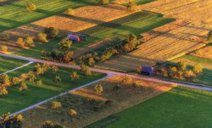
Updating the Land Parcel Identification Systems: The Benefits of Using Satellite Images for LPIS
Agricultural paying agencies across Europe face increasing challenges in maintaining accurate and up-to-date Land Parcel Identification Systems (LPIS), ensuring compliance with the Common Agricultural Policy (CAP) and supporting sustainable agricultural practices.

EUSI Confirms Uninterrupted Satellite Imagery Support for Ukraine and European Security
With the successful launch of Maxar Intelligence’s second set of WorldView Legion satellites, European Space Imaging (EUSI) will soon offer up to eight daily collection opportunities in key latitudes across Europe and North Africa – a number that will increase after the final WorldView Legion satellites are launched and all six satellites are operational.

Civil Mapping: Three Case Studies From Germany
Three land-surveying authorities finished large-scale mapping projects using very high resolution satellite images in 2024. These are the challenges, solutions and results:


