
Maritime Domain Awareness in European Arctic Regions With VHR Satellite Intelligence
With the Arctic warming nearly four times faster than the average, the ice in the High North is melting and the sea is becoming increasingly navigable. In 2025 alone, 1812 vessels entered the Arctic Polar Code area, which is a 40% increase since 2013 when data collection began. While this rise in traffic presents potential commercial opportunities, more vessels also mean more risks to people and resources.
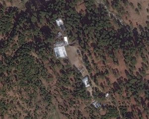
PAKISTAN: Satellite Imagery confirms India missed target in Pakistan airstrike
A satellite image captured by WorldView-2 on 27 February 2019 confirms that the religious school run by Jaish-e-Mohammed in northeastern Pakistan appears to still be

Highly Automated Beach Litter Detection
Tama Group is using machine learning along with Very High Resolution 30 cm satellite imagery supplied by European Space Imaging to create a highly automated
Rapid Delivery of Satellite Imagery Within a Small Weather Window: Middle Black Sea Region, Turkey
Satellite Tasking Solutions Case Study In 2017, European Space Imaging partner, NiK System was tasked with the acquisition and processing of Very High Resolution (VHR)
Smarter Decision Making from Space
Very High Resolution satellite imagery has become an invaluable resource for many government functions, writes Adrian Zevenbergen, European Space Imaging. Satellites view the Earth as
Powering the future of location intelligence: Earth imaging basics
By: Josh Winer, DigitalGlobe Senior Sales Manager We’ve all interacted with imagery of our planet in one form or another. Whether on our mobile devices,

Border Control in Melilla: A Very High Resolution Look
Very High Resolution (VHR) satellite imagery supplied by European Space Imaging plays a crucial role in monitoring high traffic migration areas like Melilla, Spain where
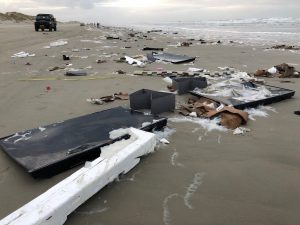
Near-Real-Time Satellite Imagery Aids in Beach Cleanup Efforts
On January 2, 2019, the MSC Zoe lost up to 270 containers off the coast of Germany and The Netherlands. As the debris, including chemicals,
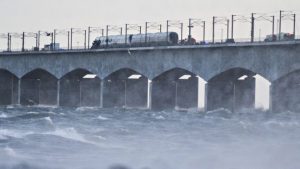
Satellite Images: Denmark Train Collision Location
Share on facebook Share on twitter Share on linkedin Related Stories

Major Oil Spill in the Mediterranean
French and Italian maritime authorities have commenced cleaning a major spill that has spread 20 kilometers in the Mediterranean Sea after two cargo ships collided

European Space Imaging, €20 Million Maritime Contract
European Space Imaging has been awarded its third major contract for the provision of very high resolution optical satellite data to the European Maritime Safety
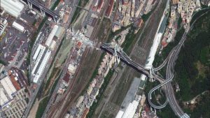
Satellite Images of Morandi Bridge Collapse
Satellite imagery supplied by European Space Imaging highlights the devastating extent of damage that was sustained to the Morandi Bridge as it collapsed during a
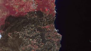
Satellite Images Show Devastation Wrought by Greek Forest Fires
More than 80 people have been killed and thousands of homes destroyed by forest fires in Attica, Greece. In the wake of devastating forest fires


