Since the launch of the first commercial VHR optical satellite, we have been a leader in providing the highest quality satellite imagery in the world. Whether your project requires historical imagery from the archive, a fresh collection over your area of interest or massive amounts of data ingestion, we can guide you to the perfect solution.
Since 2002, we have been a leader in providing the highest quality satellite imagery in the world. Whether your project requires historical imagery from the archive, a fresh collection over your area of interest, massive amounts of data ingestion, or even SAR and multispectral imagery, we can guide you to the perfect solution.
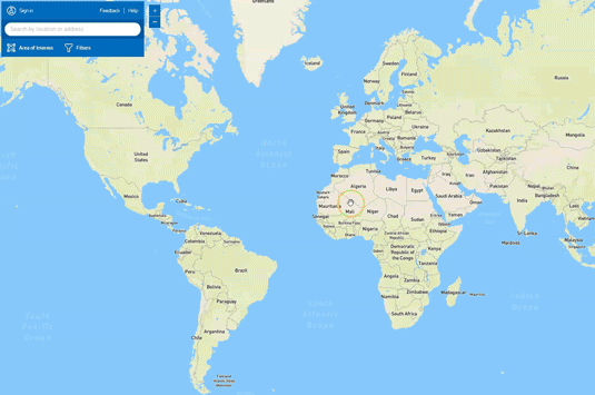
Get instant access to the most comprehensive archive of VHR satellite imagery in the world. This powerful tool lets you search and filter billions of square kilometers of imagery, create AOI shapefiles and obtain all the info you need to order imagery seamlessly.
* Images in the library are not viewed at full resolution. For full resolution image streaming, please see SecureWatch
Satellite Tasking
Put the control in your own hands. When pre-existing imagery won’t work for your project, then you can take advantage tasking a satellite to take the image you need, when you need.
With access to dozens of orbiting satellites from Maxar, our users get several opportunities every day to collect the perfect image.
Work personally with our team of experts for feasibilities studies and to specify:
Combined VHR Optical and SAR tasking provides a reliable solution for comprehensive insights, unaffected by weather conditions or daylight variations. By utilizing a single tasking source for both datasets, it ensures synchronized collections, which help in eliminating data gaps during monitoring missions. This seamless integration allows for continuous and accurate observation, enhancing the overall quality of the data. Additionally, the inclusion of SAR (Synthetic Aperture Radar) technology offers the advantage of penetrating clouds and capturing data in all weather conditions, providing deeper insights and complementing optical data for a more complete analysis.
When your organisation’s business decisions require you to identify small features on the ground, an improved visual experience is key. True 30 cm resolution imagery has long been the industry leader in clarity. Now with innovative proprietary technology from Vantor applied to native 30 cm data, 15 cm HD imagery provides the next level of detail – enhancing manual and automated feature extraction efforts from satellite imagery.
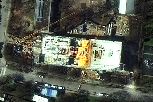
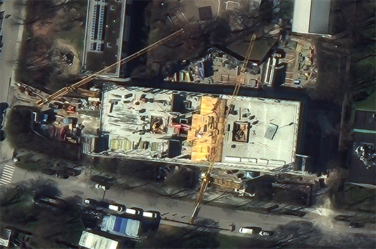
Redefining low latency data, European Space Imaging (EUSI) offers Near Real-Time (NRT) satellite image delivery in only 15 minutes after collection. The EUSI DAF 3.0 ground station features the most advanced satellite downlinking and processing technology. This not only enables the 15 minute imagery delivery but also the ability to process multiple NRT orders simultaneously. The impact of such low latency Very high Resolution satellite imagery is wide reaching across security, maritime and emergency response applications.
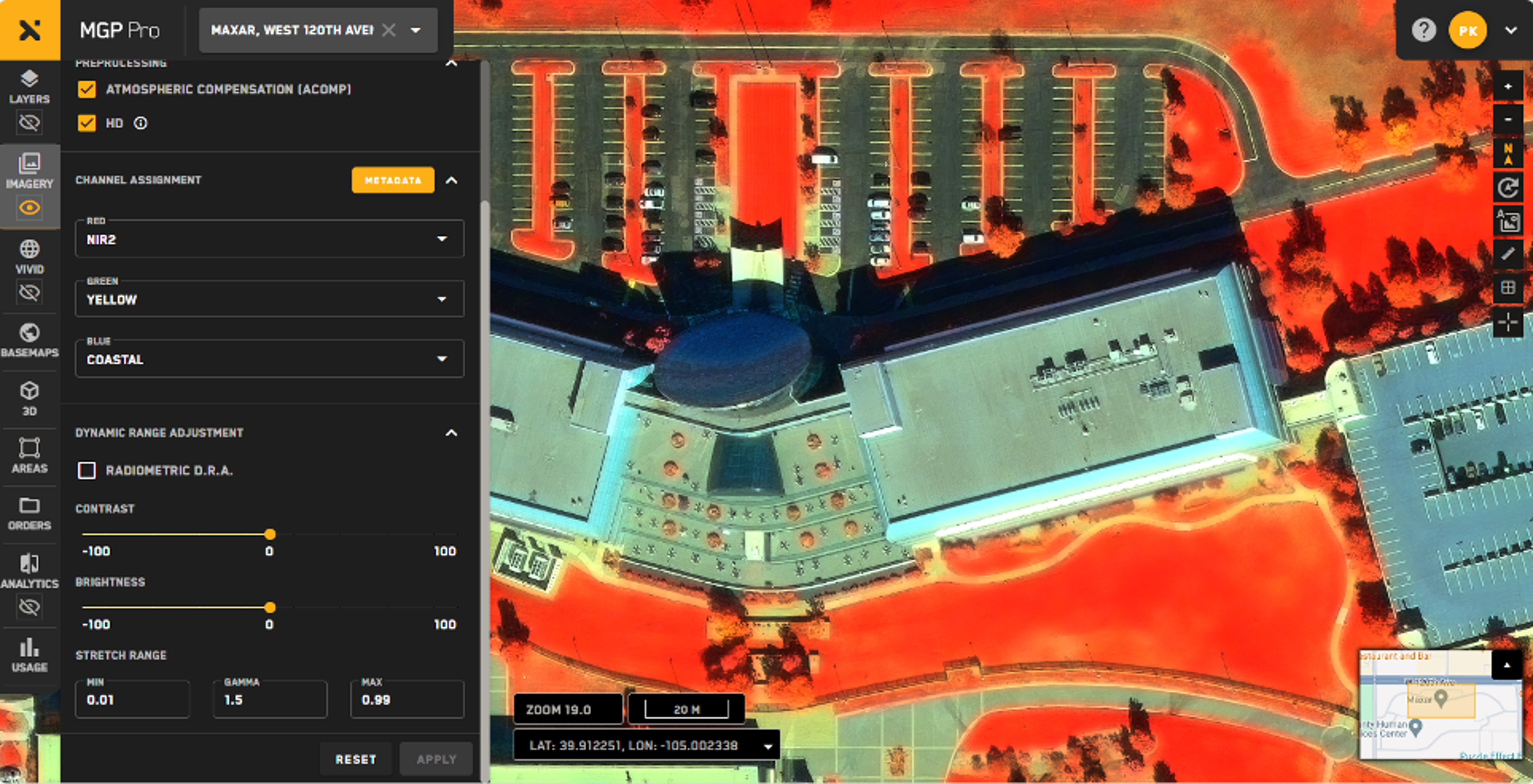
MGP Pro is the premier, cloud-based subscription platform for secure and timely access to Earth Intelligence. With a broad range of imagery and geospatial data products, MGP Pro provides unrivaled coverage, quality and flexibility. MGP Pro subscribers can access over 3 million square kilometers of daily image collections, plus more than 6 billion sq km of archived imagery at up to 30 cm resolution.
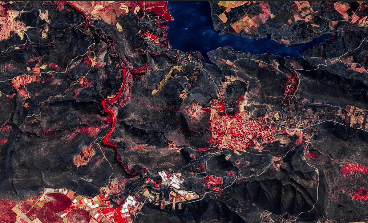
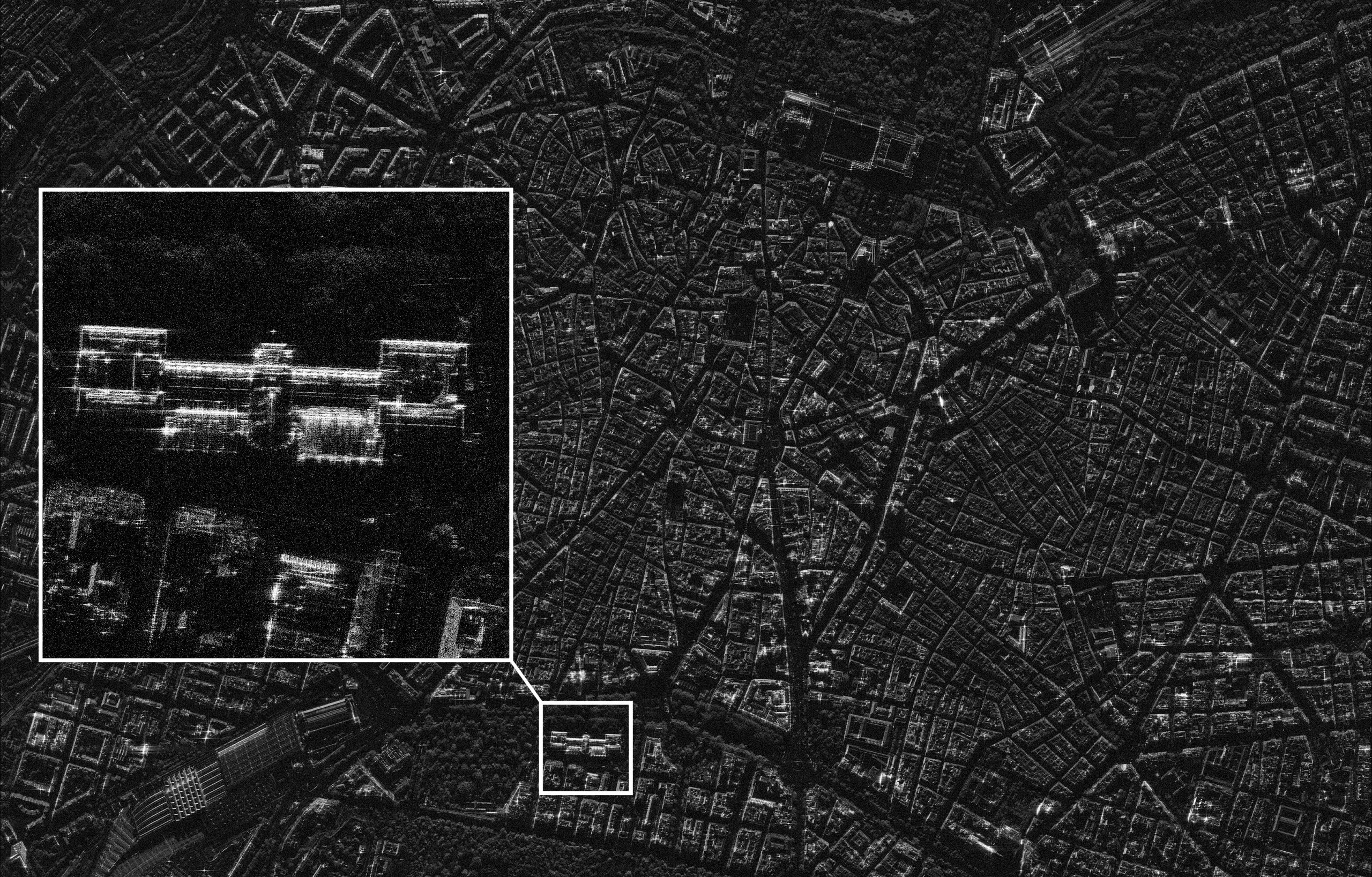
Through a strategic partnership with Umbra, European Space Imaging (EUSI) now offers the world’s highest quality space-based Synthetic Aperture Radar (SAR) imagery. With an ever-expanding range of scanning modes, SAR imagery is available in different sized footprints with resolutions as high as 25 cm. All weather tasking and delivery tailored for emergency and security applications means it’s a perfect option for coupling with VHR optical imagery to ensure you receive usable data at all hours regardless of weather.
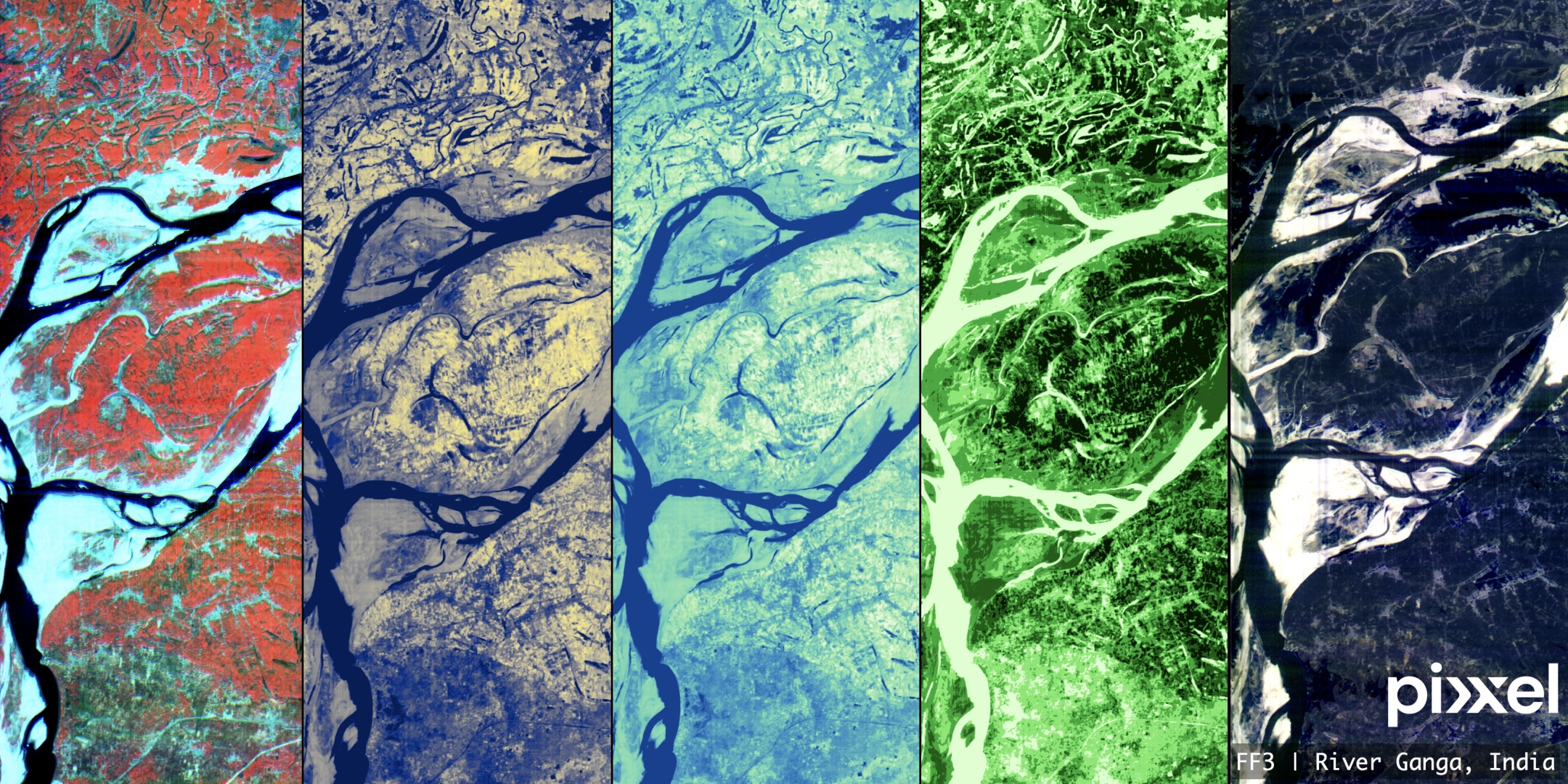
Through a tactical collaboration with Pixxel, European Space Imaging (EUSI) now provides access to the world’s most advanced hyperspectral imagery, capturing information across up to 250 bands with 5-meter resolution and daily revisits. This partnership unlocks unparalleled capabilities for detecting features and materials in sectors such as agriculture, energy, mining, and forestry. Pixxel’s unique sensor features, combined with EUSI’s expertise in building insights and products, enable precise change detection and decision-making, setting a new benchmark for remote sensing applications.
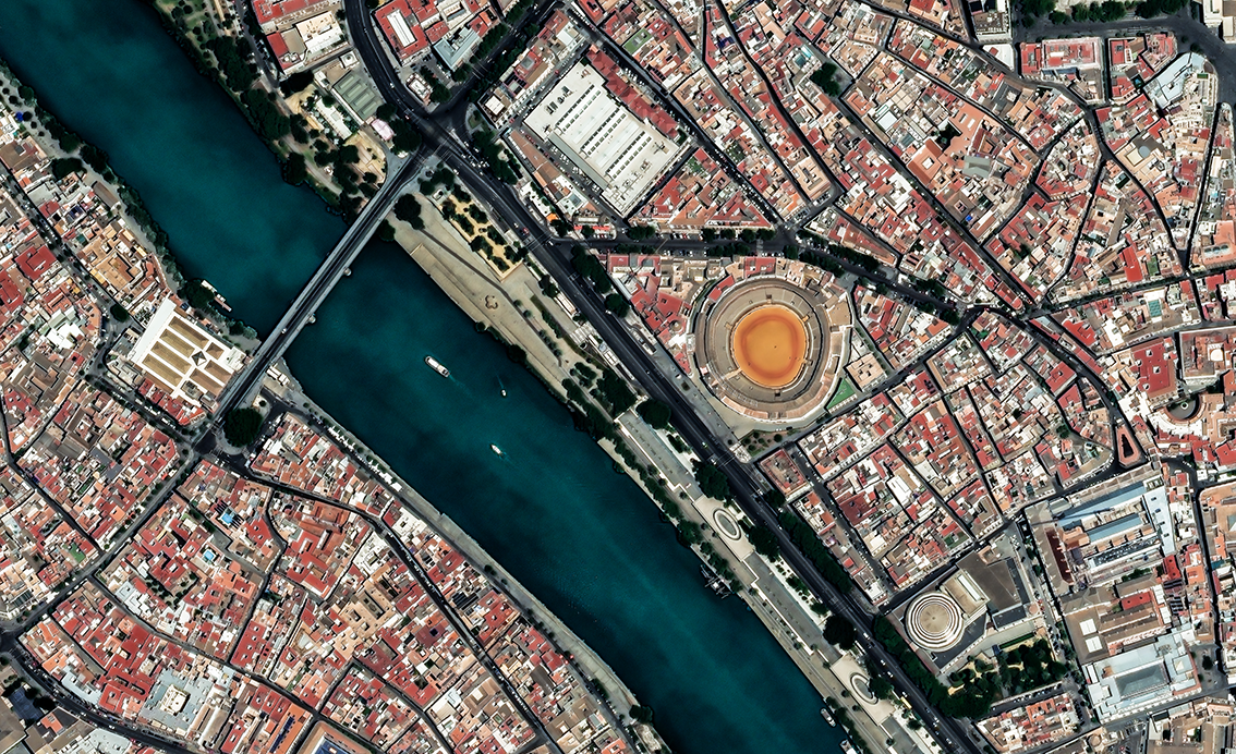
UrbanPix HD is a curated dataset of key European metro areas collected at least once per year in triple stereo, facilitating the HD dynamic mosaics. The list of cities is curated by a joint effort from the EU Commission, DLR and EUSI and include climate neutral cities and rapidly developing urban areas.
This dataset is key in promotions towards the EU Commission, ESA, and sustainability/urban development customers.
For our high volume users we offer flexible API ordering and data ingestion framework. The European Space Imaging ordering API is a REST based interface enabling searching and ordering of the entire European Space Imaging and Maxar imagery archive. The system allows for the production of ortho-ready standard and orthorectified imagery, according to the specifications in the product guide.
This website uses cookies to improve your experience. We'll assume you're ok with this, but you can opt-out if you wish.DENYCUSTOMIZEACCEPT ALL
Privacy & Cookies Policy
Privacy Overview
This website uses cookies to improve your experience while you navigate through the website. Out of these cookies, the cookies that are categorized as necessary are stored on your browser as they are essential for the working of basic functionalities of the website. We also use third-party cookies that help us analyze and understand how you use this website. These cookies will be stored in your browser only with your consent. You also have the option to opt-out of these cookies. But opting out of some of these cookies may have an effect on your browsing experience.
Necessary cookies are absolutely essential for the website to function properly. This category only includes cookies that ensures basic functionalities and security features of the website. These cookies do not store any personal information.
Any cookies that may not be particularly necessary for the website to function and is used specifically to collect user personal data via analytics, ads, other embedded contents are termed as non-necessary cookies. It is mandatory to procure user consent prior to running these cookies on your website.
Architecture of ResNet34-UNet model
UNet architecture for semantic segmentation with ResNet34 as encoder or feature extraction part. ResNet34 is used as an encoder or feature extractor in the contracting path and the corresponding symmetric expanding path predicts the dense segmentation output.
Architecture of VGG16-UNet model
UNet architecture for semantic segmentation with VGG16 as the encoder or feature extractor. VGG16 is used as an encoder or feature extractor in the contracting path and the corresponding symmetric expanding path predicts the dense segmentation output.
Architecture of ResNet34-FCN model
In this model, ResNet34 is used for feature extraction and the FCN operation remains as is. The feature of ResNet architecture is exploited where just like VGG, as the number of filters double, the feature map size gets halved. This gives a similarity to VGG and ResNet architecture while supporting deeper architecture and addressing the issue of vanishing gradients while also being faster. The fully connected layer at the output of ResNet34 is not used and instead converted to fully convolutional layer by means of 1×1 convolution.
Architecture of VGG16-FCN model
In this model, VGG16 is used for feature extraction which also performs the function of an encoder. The fully connected layer of the VGG16 is not used and instead converted to fully convolutional layer by means of 1×1 convolution.