


EUSI Confirms Uninterrupted Satellite Imagery Support for Ukraine and European Security
With the successful launch of Maxar Intelligence’s second set of WorldView Legion satellites, European Space Imaging (EUSI) will soon offer up to eight daily collection opportunities in key latitudes across Europe and North Africa – a number that will increase after the final WorldView Legion satellites are launched and all six satellites are operational.
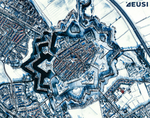
What do Star Forts Look Like From Space? 20 Satellite Images That Will Take Your Breath Away
Star forts are not only perfect examples of effective military engineering; they are also beautiful. Let’s join us on a fascinating journey through architecture and history – from space. All satellite images in this article were collected by WorldView-3, WorldView-2 or GeoEye-1 at 30–50 cm resolution.

How 8-Band Multispectral VHR Satellite Imagery Sees Through Smoke in the Mediterranean Fires
As forest fires tear through multiple nations around the Mediterranean Sea, European Space Imaging (EUSI)


