A multi-source IMINT-GEOINT data management and analytics platform
A dedicated big data platform
Highly Compatible
Easily ingest data through SecureWatch, AIS, Sentinel, ACLED, and more
Data management
Easy-to-use interface with advanced search and filter capabilities
powerful analytics
Label, compare, detect and identify features in any raster or vector dataset
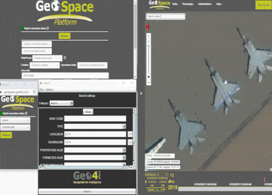
Geo4i’s GeoSpace is a dedicated GEOINT & IMINT platform for processing and analysing geospatial imagery and Big Data. The platform is NATO STANAG 3596 compliant featuring automated detection workflows and other value-added tools allows for reporting and analysis. The intuitive interface and addons assist a range of applications with features including:
Help4i provides accurate, intuitive and easy to understand identification of civilian and military equipment with more than 6,000 items registered in the GeoSpace platform. With just a few measurements, you can refine the search to a list of potential candidates matching the equipment to be identified with functionality to overlap and compare models and thereby improve the confidence of the identification.
The product can be purchased as a stand-alone software option or as an add on tool of Geospace.
Sites4i is a module of GeoSpace providing a digitalisation and labelling environment to perform IMINT tasks.
Features include:
NATO STANAG 3596-compliant
Multi-temporal versioning
Dedicated resources to assist photo-interpretation
Sharing and reporting capabilities
ADD THE AI CHAIN FOR AUTOMATED DETECTION
The AI Chain from Geo4i is a GEOINT & IMINT API environment for the automatic detection of generic objects in satellite images. The product can be integrated into GeoSpace and is based on TensorFlow, tailored to fit D&I needs.
The training set is generated by the user’s imagery and the product can be deployed within the customers secured infrastructure.
A SecureWatch subscription gives you instant access to the best satellite imagery and geospatial data via web browser or API integration; And you don’t have to be an imagery expert or have in-house tools.
SecureWatch is designed to make both fresh and archive imagery accessible to anyone who needs it, whether you’re concerned with a specific area or the entire globe.
This website uses cookies to improve your experience. We'll assume you're ok with this, but you can opt-out if you wish.DENYCUSTOMIZEACCEPT ALL
Privacy & Cookies Policy
Privacy Overview
This website uses cookies to improve your experience while you navigate through the website. Out of these cookies, the cookies that are categorized as necessary are stored on your browser as they are essential for the working of basic functionalities of the website. We also use third-party cookies that help us analyze and understand how you use this website. These cookies will be stored in your browser only with your consent. You also have the option to opt-out of these cookies. But opting out of some of these cookies may have an effect on your browsing experience.
Necessary cookies are absolutely essential for the website to function properly. This category only includes cookies that ensures basic functionalities and security features of the website. These cookies do not store any personal information.
Any cookies that may not be particularly necessary for the website to function and is used specifically to collect user personal data via analytics, ads, other embedded contents are termed as non-necessary cookies. It is mandatory to procure user consent prior to running these cookies on your website.
Architecture of ResNet34-UNet model
UNet architecture for semantic segmentation with ResNet34 as encoder or feature extraction part. ResNet34 is used as an encoder or feature extractor in the contracting path and the corresponding symmetric expanding path predicts the dense segmentation output.
Architecture of VGG16-UNet model
UNet architecture for semantic segmentation with VGG16 as the encoder or feature extractor. VGG16 is used as an encoder or feature extractor in the contracting path and the corresponding symmetric expanding path predicts the dense segmentation output.
Architecture of ResNet34-FCN model
In this model, ResNet34 is used for feature extraction and the FCN operation remains as is. The feature of ResNet architecture is exploited where just like VGG, as the number of filters double, the feature map size gets halved. This gives a similarity to VGG and ResNet architecture while supporting deeper architecture and addressing the issue of vanishing gradients while also being faster. The fully connected layer at the output of ResNet34 is not used and instead converted to fully convolutional layer by means of 1×1 convolution.
Architecture of VGG16-FCN model
In this model, VGG16 is used for feature extraction which also performs the function of an encoder. The fully connected layer of the VGG16 is not used and instead converted to fully convolutional layer by means of 1×1 convolution.