
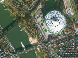
Large-scale Mapping: 7 Important Factors to Consider When Choosing Between Aerial and Satellite Sensors
Member states and regional mapping agencies are often split on preferring aerial or satellite datasets. Which one is better? Users should carefully compare the two platforms to ensure the best data collection for their project. While a combined approach using satellite imagery to fill missing aerial data gaps can be effective, many organisations at both EU and national levels depend solely on VHR satellite data for successful wide area coverage. Here are 7 major factors to consider.
Maxar WorldView Legion Satellites: The Successful Launch & Its Impact on EO Applications in Europe
WorldView Legion satellites collect at 30 cm-class resolution, offer 8 spectral bands (some of which are different from WorldView-3), and increase Maxar’s imaging capacity to 6.6 million km2 a day. What are the specifications of the imagery? What technical innovations make the satellites smaller yet as powerful as their predecessors? And how does their unprecedented revisit rate transform critical sectors like defence and disaster response? Learn about the technical parameters and real-world applications of Maxar WorldView Legion in this article.
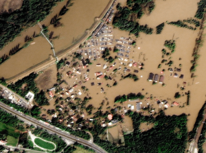
Synchronised Collections of SAR and VHR Optical Satellite Imagery Revolutionise Flood Management
As climate change accelerates, the frequency and severity of flooding events are becoming increasingly alarming. In response, innovative tools like DoubleShot, developed by European Space Imaging in partnership with Umbra, are transforming flood management strategies. By combining the power of Very High Resolution (VHR) Synthetic Aperture Radar (SAR) and Optical satellite imagery, DoubleShot delivers a comprehensive, weather-independent solution for near real-time flood mapping and monitoring.


