

TURKEY-GREECE BORDER: Satellite Images Show Refugee Crisis
- European Space Imaging
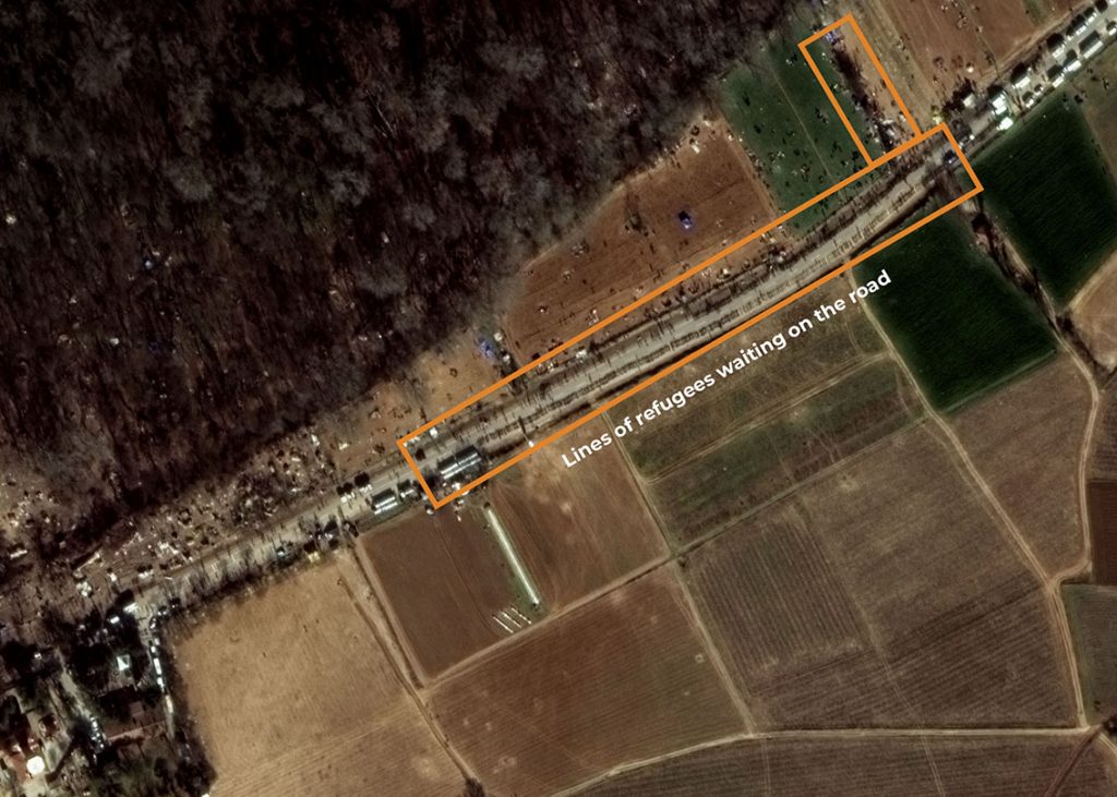
Thousands of refugees wait patiently in line at the Turkey border, as they await passage into Greece.
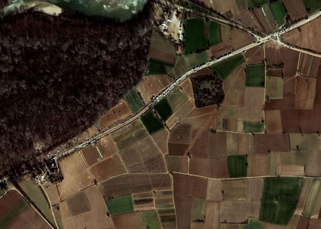
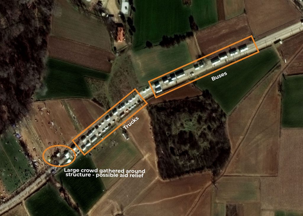
Satellite images captured early on 3 March, 2020 with WorldView-3 by European Space Imaging, show long lines of refugees on the road, numerous buses and trucks, as well as temporary housing facilities scattered adjacent to the road, extending well into the nearby forest.
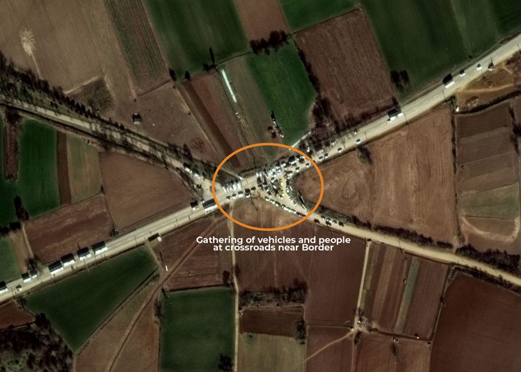
Several buses on the road towards the border are clearly identifiable, correlating with reports that refugees are being bused to the area. In addition, numerous smaller vehicles with crowds of people surrounding can be seen. This could be indicative of aid support in the area. For security and safety, the border is being closely monitored by Frontex to mitigate any crises that could arise. “We are looking at other ways to help EU countries that border Turkey,” the agency said.
“Very High Resolution satellite imagery is both a cost-effective and time-efficient method of monitoring European borders as it allows identification of small objects in near real-time,” said Adrian Zevenbergen, Managing Director, European Space Imaging. “Country borders can run across long distances of differing terrain and people are small. Monitoring these areas frequently enables us to track refugee movements in order to ensure their safety.”
European Space Imaging will continue to monitor this situation and make images available as soon as possible.
Satellite image at 30 cm resolution showing overview of refugees, tents, trucks, buses and aid relief at the Turkey / Greece Border. Captured 03/03/2020 by WorldView-3 © European Space Imaging
Satellite image at 30 cm resolution showing lines of refugees on the road at the Turkey / Greece Border. Captured 03/03/2020 by WorldView-3 © European Space Imaging
Satellite image at 30 cm resolution showing buses, trucks and potential aid relief zone at the Turkey / Greece Border. Captured 03/03/2020 by WorldView-3 © European Space Imaging
Satellite image at 30 cm resolution showing potential aid relief zone set up at a crossroads near the Turkey / Greece Border. Captured 03/03/2020 by WorldView-3 © European Space Imaging
Related Stories

Earth Observation Turns Ecological Targets into Measurable Outcomes: How Satellite Imagery Supports Compliance with Europe’s Nature Restoration Regulation
The EU’s Nature Restoration Regulation (NRR) entered into force in 2024 and set legally binding targets to restore degraded ecosystems across Europe. With National Restoration Plans due in September 2026, Member States face an urgent question: how do you map, plan and monitor restoration across millions of hectares in a consistent, verifiable way? Earth Observation (EO) – and Very High Resolution (VHR) multispectral satellite imagery in particular – is increasingly the answer.

EUSI Upgrades German Ground Segment to Enable Europe’s Fastest Request-to-Receive Satellite Intelligence via Secure Web and API Platform for Defence and Emergency Agencies
European Space Imaging (EUSI) announced a major upgrade of its satellite ground segment and cloud infrastructure, further accelerating its industry-leading satellite tasking and intelligence delivery capabilities through the secure ATOM™ web and API platform. The platform, in combination with EUSI’s Rapid Satellite Intelligence (RSINT) program, enables satellite tasking up to 30 minutes before image acquisition and delivery of imagery within 15 minutes of collection.


Maritime Domain Awareness in European Arctic Regions With VHR Satellite Intelligence
With the Arctic warming nearly four times faster than the average, the ice in the High North is melting and the sea is becoming increasingly navigable. In 2025 alone, 1812 vessels entered the Arctic Polar Code area, which is a 40% increase since 2013 when data collection began. While this rise in traffic presents potential commercial opportunities, more vessels also mean more risks to people and resources.

Seeing More in a Single Day: The Value of Intraday Satellite Collections
Imagine a convoy moves between 08:00 and 11:00. Or morning clouds clear by 14:00, revealing new activity. Or a structure appears at 09:30 that wasn’t visible at 07:00. If you’re working with once-daily satellite passes, you miss all of this. With intraday collections, you see it happen.




