


European Space Imaging Partner in Newly Launched MARSAT Consortium

MARSAT consortium announced it is ready to provide innovative space-based applications using satellite-derived information for the maritime and coastal industry. MARSAT’s main goal is to create integrated satellite-based services to improve safety and efficiency in shipping, offshore industries, emergency response and rescue operations.

“MARSAT is an ambitious project, which brings together competence of specialists in satellite data provision and analysis, IT and the maritime industry. This team will lay the ground for improved decision making for shipping route optimization, offshore planning and maintenance as well as emergency events”, said Dr. Knut Hartmann, Project Coordinator MARSAT, EOMAP GmbH & Co KG

MARSAT is a consortium of six German companies, EOMAP GmbH & Co KG, Drift & Noise Polar Services GmbH, European Space Imaging GmbH, Institute of Shipping Economics and Logistics (ISL), SevenCs GmbH, TRENZ AG, and is funded by BMWi, the German Federal Ministry for Economic Affairs and Energy. The kick-off meeting was successfully held at the end of August 2016 at the German Aerospace Center (DLR) Space Administration in Bonn, Germany and marked the starting point of this 2.5 year project.

MARSAT – Satellite Services for the Maritime Industry

“The use of satellite data and Earth Observation products in the maritime world has an enormous potential. We are at the very beginning, just starting to get a glimpse at the possibilities and huge benefits these innovative technologies will offer.” Dr. Nils Meyer-Larsen, Project Manager, ISL

The technical goals of MARSAT are to create and integrate operational services to allow the maritime industry to take advantage of the most up-to-date satellite information in their day-to-day work. This requires setting up an efficient IT infrastructure to share, integrate and implement satellite-derived data quickly and efficiently from various satellite sources. Services such as ice detection and drift, obstruction and bathymetry mapping will be integrated in maritime information systems so that, e.g., shipping routes can be optimized, up-to date information made available for rescue or emergency events, and base data provided for environmental and coastal use cases within user friendly applications.

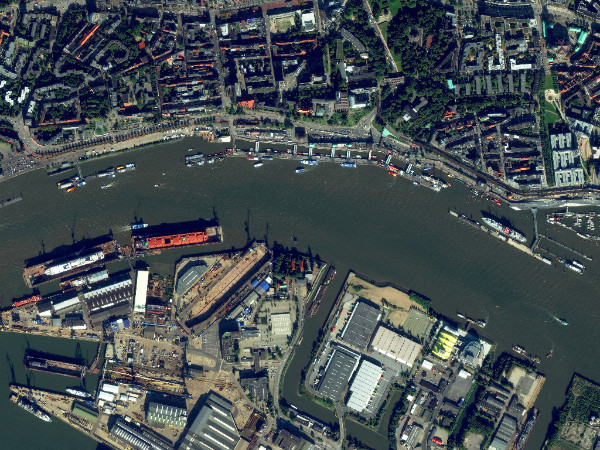
Port facilities in Hamburg, Germany imaged by WorldView-2, 3 Oct 2015.

“European Space Imaging believes in the potential of the Earth Observation industry to offer integrated, more user-friendly and sustainable services to the maritime industry. By uniting satellite-based information services into existing maritime information structures we will create better services and provide more safety in the industry,” says Adrian Zevenbergen, Managing Director, European Space, Imaging.

MARSAT is a dynamic and steadily growing network of data suppliers, users and academia, and cooperation is more than welcome.

Related Stories

Nature Restoration

Earth Observation Turns Ecological Targets into Measurable Outcomes: How Satellite Imagery Supports Compliance with Europe’s Nature Restoration Regulation

The EU’s Nature Restoration Regulation (NRR) entered into force in 2024 and set legally binding targets to restore degraded ecosystems across Europe. With National Restoration Plans due in September 2026, Member States face an urgent question: how do you map, plan and monitor restoration across millions of hectares in a consistent, verifiable way? Earth Observation (EO) – and Very High Resolution (VHR) multispectral satellite imagery in particular – is increasingly the answer.

Read More »
satellite antenna

EUSI Upgrades German Ground Segment to Enable Europe’s Fastest Request-to-Receive Satellite Intelligence via Secure Web and API Platform for Defence and Emergency Agencies

European Space Imaging (EUSI) announced a major upgrade of its satellite ground segment and cloud infrastructure, further accelerating its industry-leading satellite tasking and intelligence delivery capabilities through the secure ATOM™ web and API platform. The platform, in combination with EUSI’s Rapid Satellite Intelligence (RSINT) program, enables satellite tasking up to 30 minutes before image acquisition and delivery of imagery within 15 minutes of collection.


Read More »
Ship in Arctic waters

Maritime Domain Awareness in European Arctic Regions With VHR Satellite Intelligence 

With the Arctic warming nearly four times faster than the average, the ice in the High North is melting and the sea is becoming increasingly navigable. In 2025 alone, 1812 vessels entered the Arctic Polar Code area, which is a 40% increase since 2013 when data collection began. While this rise in traffic presents potential commercial opportunities, more vessels also mean more risks to people and resources.

Read More »




