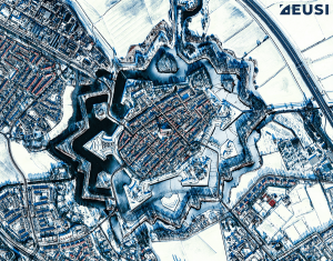
What do Star Forts Look Like From Space? 20 Satellite Images That Will Take Your Breath Away
Star forts are not only perfect examples of effective military engineering; they are also beautiful. Let’s join us on a fascinating journey through architecture and history – from space. All satellite images in this article were collected by WorldView-3, WorldView-2 or GeoEye-1 at 30–50 cm resolution.
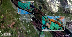
EUSI and Pixxel Partner to Bring the World’s Best Hyperspectral Imagery to the European Market
Munich, Germany, Los Angeles, California, and Bangalore, India – European Space Imaging (EUSI), a leading

Overcoming Limitations in Satellite Imagery: The Power of Intelligent Collection Planning
Automated collection planning systems come with limitations. That’s why in European Space Imaging (EUSI), we


