Intelligent Collection Planning (ICP)
The key to more efficient collection of large areas and difficult weather conditions

Superior TASKING for your project
Scalable Tasking
Flexible collection planning that meets the needs of any sized project
< 15% Cloud Coverage
Expert human intervention for weather analysis at continuous intervals
Unbeatable Efficiency
Experience, planning and flexibility that consistently leads to success
European regions are notorious for rapidly changing weather conditions, yet the demand for up-to-date Very High Resolution (VHR) satellite imagery covering the whole continent persists. Regardless if the needs are for large-scale mapping or agriculture monitoring, Intelligent Collection Planning (ICP) by European Space Imaging (EUSI) is the solution.
Planning new imagery collection is a fine balance between the satellite’s capabilities, knowledge of local weather patterns and effective scheduling. While most satellite imagery providers rely solely on automation to schedule tasking, we introduce expert human intervention every 15 minutes until collection to continuously optimize every pass of the satellites. This ensures that our customers always have the highest chance of receiving their image on-time and matching their parameters.
For large-scale collections, in particular within a certain season or time frame, this means the customer receives a more homogenous dataset that is on-time and within budget.
See how our imagery fits your project
Download imagery, mapping and 3D product samples.
Whole Country Coverages
The implementation of the EU’s “New CAP” has dramatically increased the demand for VHR satellite coverage of entire member states. Where before, the EU Commission organized the collection of 30cm satellite imagery to verify land use and agricultural subsidies, the onus is now on individual member states.
EUSI plans to collect all major participating member states in their entirety multiple times per year, giving Ministries of Agriculture and paying agencies ample opportunity to analyze the vegetation seasons in their countries.

Imagery Basemaps
When you rely on map data to make decisions about your community or serve your customers, you need accurate information that meets your requirements. Maxar’s Vivid and Dynamic imagery basemaps feature the latest innovations in mosaicking, color balancing and image processing to provide stunning high-resolution, high-accuracy image layers available off the shelf or configured on demand. Imagery basemaps provide a virtually seamless, consistent image layer over large areas to support mapping, visualisation, and analytics. Spend less time processing data and more time executing your mission.
Multiple Daily Opportunities
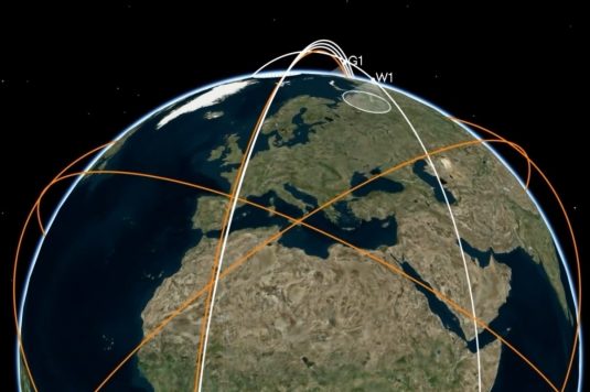
The Maxar Worldview Legion constellation begins launching in 2023, enabling EUSI a 3x increase in 30 cm collection capacity. With up to 15 daily revisits over key regions in Europe, we can ensure that large scale tasking projects are completed even faster and the goals of multiple yearly country coverages are achieved.
More collections throughout the day also allow users to compare data sets from morning until evening for more nuanced analysis.
Small Weather Windows
Many regions in Europe are known for cloudy weather and long winters. This can mean short vegetation seasons for satellite imagery collections, narrow migration seasons for wildlife and small weather windows for volatile regions.
Our human-assisted weather monitoring and tasking flexibility enables us unprecedented success where other imagery providers fall short. The operations team at EUSI has decades of combined experience in planning and executing even the most challenging satellite imagery collection scenarios.


