

Greece: Satellite Images Show Oil Spill
- European Space Imaging
A tanker carrying 2,500 tonnes of oil and fuel sank near Athens on September 10, polluting the Greek coastline.
European Space Imaging captured a series of satellite images of the site between September 13 and 15, using Digital Globe’s satellite GeoEye-1.
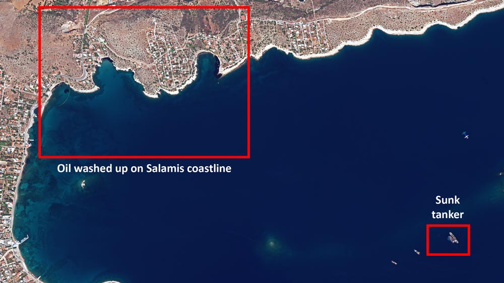
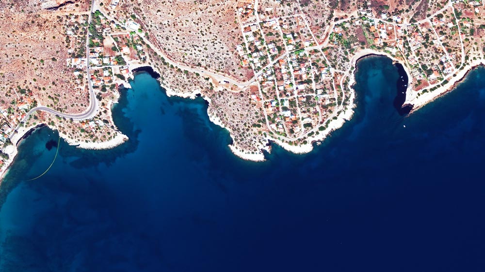
“The very high resolution satellite images show us precisely where the oil is,” says Dr Melanie Rankl of European Space Imaging. “They reveal that it has spread over more than 1.5km of the Salamis coastline, and a smaller amount has traveled south to the Attica coast.”
13 September 2017 | An overview of the oil spill scene | GeoEye-1
13 September 2017 | Black oil is clearly visible on the coast of Salamis | GeoEye-1
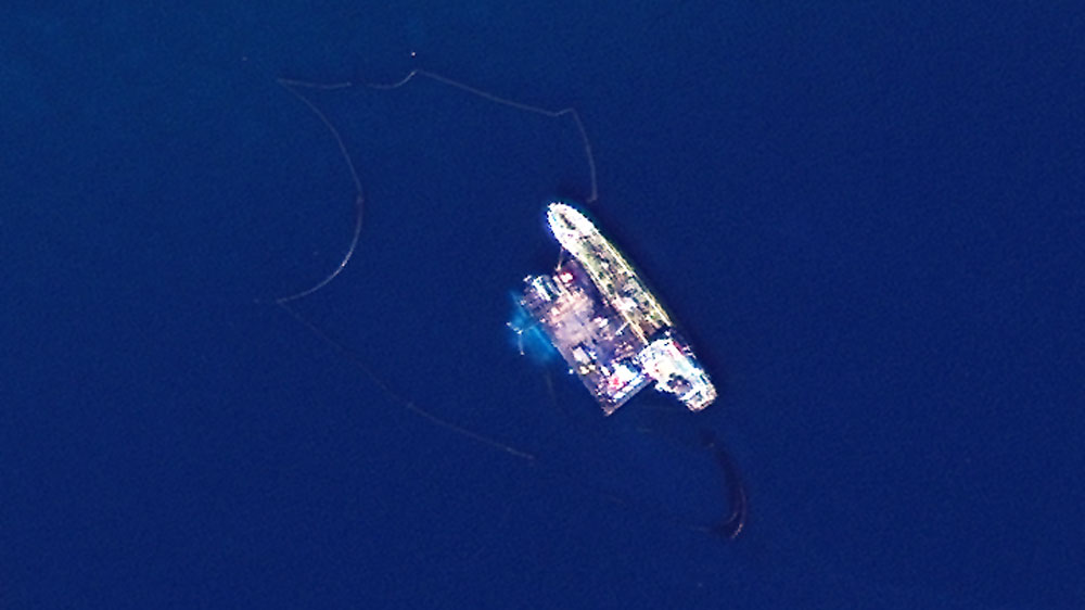
13 September 2017 | Containment buoys are visible around the sunk tanker | GeoEye-1
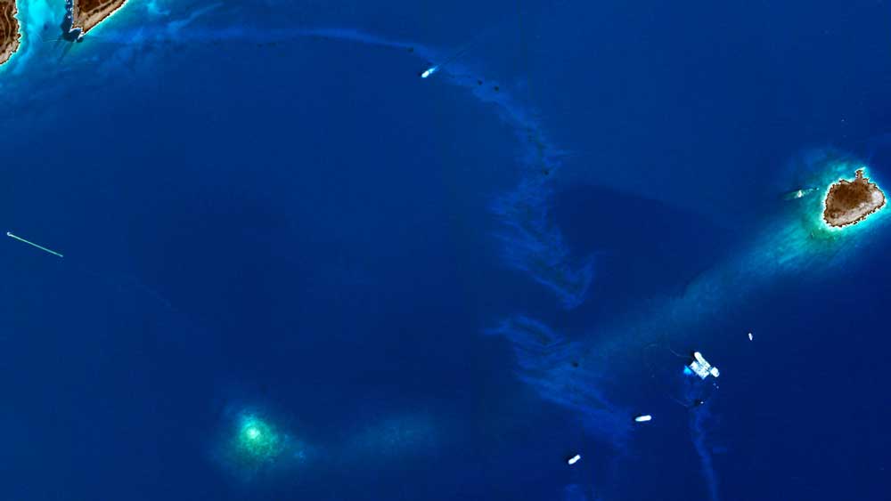
14 September 2017 | Visual analysis by European Space Imaging staff reveals the presence of oil floating between the tanker and the coast – it can seen as a lighter blue | GeoEye-1
Emergency barriers have been placed around the sunken ship and affected coastline in an effort to prevent the oil from spreading further, but when seen from space it is clear that a significant amount is still floating freely. Authorities estimate the clean-up will take more than four months.
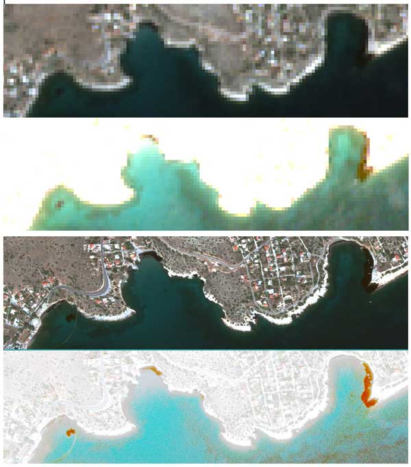
Just seven minutes after GeoEye-1 collected images of the site, the European Space Agency satellite Sentinel-2A did the same. This allowed the DLR Maritime Safety and Security Lab in Neustrelitz, Germany, to compare GeoEye-1’s 50cm resolution data with Sentinel-2A’s 10m resolution data.
“The red-brown areas of the processed images represent probable oil pollution,” says Egbert Schwarz, Head of the Lab. “So while the suspected spill is visible in the Sentinel-2A image, it is the clarity in the high resolution GeoEye-1 image that allows us to confirm our suspicions.”
13 September 2017 | A comparison prepared by the DLR Maritime Safety and Security Lab shows the difference in the 10m resolution data from Sentinel-2 (upper two images, © Copernicus data [2017]) and the 50cm resolution data from GeoEye-1 (lower two images, © European Space Imaging).
Salamis lies south of Eleusis, where the majority of Greece’s crude oil is imported and refined. It is thought to be one of the most polluted areas in Greece, but the oil spill represents a local environmental disaster.
“The satellite imagery not only allows authorities to assess the extent of the environmental damage, it may also be used to investigate possible causes of the incident,” says Dr Rankl.
It is unclear why the Agia Zoni II sunk, as weather conditions were good at the time and the vessel was at anchor. The ship was built in 1972 and was capable of carrying 3,205 tonnes – it flew the Greek flag.
"While the suspected spill is visible in the Sentinel-2A image, it is the clarity in the high resolution GeoEye-1 image that allows us to confirm our suspicions."
Egbert Schwarz, Head of the DLR Maritime Safety and Security Lab
Related Stories

Earth Observation Turns Ecological Targets into Measurable Outcomes: How Satellite Imagery Supports Compliance with Europe’s Nature Restoration Regulation
The EU’s Nature Restoration Regulation (NRR) entered into force in 2024 and set legally binding targets to restore degraded ecosystems across Europe. With National Restoration Plans due in September 2026, Member States face an urgent question: how do you map, plan and monitor restoration across millions of hectares in a consistent, verifiable way? Earth Observation (EO) – and Very High Resolution (VHR) multispectral satellite imagery in particular – is increasingly the answer.

EUSI Upgrades German Ground Segment to Enable Europe’s Fastest Request-to-Receive Satellite Intelligence via Secure Web and API Platform for Defence and Emergency Agencies
European Space Imaging (EUSI) announced a major upgrade of its satellite ground segment and cloud infrastructure, further accelerating its industry-leading satellite tasking and intelligence delivery capabilities through the secure ATOM™ web and API platform. The platform, in combination with EUSI’s Rapid Satellite Intelligence (RSINT) program, enables satellite tasking up to 30 minutes before image acquisition and delivery of imagery within 15 minutes of collection.


Maritime Domain Awareness in European Arctic Regions With VHR Satellite Intelligence
With the Arctic warming nearly four times faster than the average, the ice in the High North is melting and the sea is becoming increasingly navigable. In 2025 alone, 1812 vessels entered the Arctic Polar Code area, which is a 40% increase since 2013 when data collection began. While this rise in traffic presents potential commercial opportunities, more vessels also mean more risks to people and resources.

Seeing More in a Single Day: The Value of Intraday Satellite Collections
Imagine a convoy moves between 08:00 and 11:00. Or morning clouds clear by 14:00, revealing new activity. Or a structure appears at 09:30 that wasn’t visible at 07:00. If you’re working with once-daily satellite passes, you miss all of this. With intraday collections, you see it happen.




